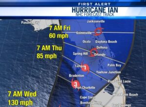
 Hurricane Ian is expected to make landfall in Florida Wednesday morning. By Thursday afternoon-Friday morning, the Panhandle will be experiencing effects. Winds will begin increasing late Tuesday through Friday; wind speeds vary from central (15-25mph) to western (35-40mph) Panhandle. Gusts up to 50mph are anticipated throughout the counties. Rainfall is projected to receive two inches or less, depending on how far to the west you are located. Northwest Florida is not projected to see major impacts; likely effects will be increased wind speeds, rain, and turbulent ocean conditions. The western side of the Panhandle is currently not expected to experience any extreme weather. They might even be lucky enough to maintain power throughout the storm.
HOWEVER, forecasts are consistently being updated so it is best to regularly check live Hurricane Ian projections to keep up-to-date. Additionally, residents are encouraged to prepare as though they will be impacted by the hurricane to stay safe. Fill your vehicles with gas, secure loose objects outside, have a healthy stock of non-perishables, and practice smart hurricane preparation. Additionally, officials are asking that everyone stay off of and out of the water from Tuesday evening until Saturday.